Help Centre

Coupon Override
Please Call
For drivers under the age of 25, additional fees and/or restrictions may apply.
For information and assistance in completing your reservation, please call:
1-855-863-0357Sorry
We're unable to find your location.

Room %{=roomIndex} Age of child %{=index}
Caribbean and Bahamas: Australia & South Pacific Panorama Voyage
Seabourn®
To travel on a Seabourn luxury world cruise is to experience two extraordinary worlds. In one, a world-class ship: all-inclusive fine dining, fine wines, spacious suites, and relaxation. The other, our world at-large: international ports, hidden coves, idyllic coastlines, diverse cultures, far-off cities, and once-in-a-lifetime landscapes. Explore up to 67 exquisite destinations across 19 countries, on this voyage meticulously crafted to immerse you in the story and soul of Australia, New Zealand, Polynesia and much more.
All onboard gratuities
Select complimentary shore excursions**
Unlimited beverages, including fine wines and premium spirits served throughout the ship
Complimentary dining venues
Complimentary in-suite bar
Complimentary caviar
Complimentary Wi-Fi packages with unlimited minutes
Welcome bottle of Champagne
Executive Member Benefit
Executive Members receive an annual 2% Reward, up to $1,250, on qualified Costco Travel purchases
Digital Costco Shop Card
Member Exclusive: Digital Costco Shop Card with every Seabourn® sailing†
Sailing Itinerary

Note: Cruise itineraries are subject to change. Please verify ports and times directly with the cruise line.
Day 1
Port of Call Miami
Departure 4:00p.m.
Overview

The City of Miami known as the “Magic City” is located in Southeast Florida, in Miami-Dade County on the Miami River, between the Florida Everglades and the Atlantic Ocean. Since its incorporation in 1896, the City has grown tremendously, transforming it into one of the world’s renowned centers where people can work, live, and play while enjoying a high quality of life. The City of Miami, known for its diverse culture and ethnicities is the largest municipality in Miami-Dade County. According to the 2000 census, it has a population of 362,470. By the year 2010, the population in the City is projected to rise to 390,191. Miami which is known as the Gateway to Latin America attracts a tremendous amount of foreign-born people, resulting in a large Latin American population that includes Cubans, Nicaraguans, Colombians, Venezuelans, Puerto Ricans, Argentineans, Ecuadorians, Brazilians, Dominicans, Haitians and Mexicans. According to the 2000 U.S. census, the City has a 60 percent Hispanic population, a 22.3 percent African-American population, and an 11.9 percent White/other population.
Day 2
Cruising
Day 3
Cruising
Day 4
Cruising
Day 5
Port of Call Cristobal/Panama
Arrival 5:00a.m.
Departure 5:00a.m.
Overview

Cristobal is a port town and county in Colon District, Colon Province, Panama with a population of 49,422 as of 2010. It is located on the western edge of Manzanillo Island, on the Atlantic side of the Panama Canal.
Day 5
Panama Canal
Overview

The Panama Canal is an artificial 48-mile waterway in Panama that connects the Atlantic Ocean with the Pacific Ocean. The canal cuts across the Isthmus of Panama and is a key conduit for international maritime trade. The Canal uses a system of locks -compartments with entrance and exit gates. The locks function as water lifts: they raise ships from sea level (the Pacific or the Atlantic) to the level of Gatun Lake (26 meters above sea level); ships then sail the channel through the Continental Divide. Each set of locks bears the name of the townsite where it was built: Gatun (on the Atlantic side), and Pedro Miguel and Miraflores (on the Pacific side). The lock chambers -steps-- are 33.53 meters wide by 304.8 meters long. The maximum dimensions of ships that can transit the Canal are: 32.3 meters in beam; draft -their depth reaches- 12 meters in Tropical Fresh Water; and 294.1 meters long (depending on the type of ship). The water used to raise and lower vessels in each set of locks come from Gatun Lake by gravity; it comes into the locks through a system of main culverts that extend under the lock chambers from the sidewalls and the center wall. The narrowest portion of the Canal is Culebra Cut, which extends from the north end of Pedro Miguel Locks to the south edge of Gatun Lake at Gamboa. This segment, approximately 13.7 kilometers long, is carved through the rock and shale of the Continental Divide. Ships from all parts of the world transit daily through the Panama Canal. Some 13 to 14 thousand vessels use the Canal every year. Commercial transportation activities through the Canal represent approximately 5% of the world trade. The Canal has a workforce of approximately 9 thousand employees and operates 24 hours a day, 365 days a year, providing transit service to vessels of all nations without discrimination.
Day 5
Port of Call Balboa/Panama
Arrival 8:00p.m.
Departure 8:00p.m.
Overview

Balboa, town (1990 pop. 2,751), Colon prov., in the former Panama Canal Zone, on the Gulf of Panama. The port for Panama City, Balboa was the administrative headquarters of the Panama Canal Zone. It was also the site of a U.S. Navy base (closed in 1999). Note that the currency of Panama is also called Balboa.
Day 6
Cruising
Day 7
Crossing the Equator
Day 8
Port of Call Guayaquil
Arrival 5:00a.m.
Departure 6:00p.m.
Overview

Guayaquil is a tropical city surrounded by hills as well as situated on the banks of an arm of the ocean and the majestic Guayas River, a setting that will captivate you with its magic of the South Pacific. It is a Renaissance city enjoying a 21st-century urban, cultural, and humanistic renaissance. Highly renowned both in Latin America and the world for its positive transformation, with original and distinctive urban creations, such as its 2 new waterfront attractions, Malecón 2000 and Malecon del Salado, Guayaquil has kilometers of botanic gardens, monuments, theatres, museums, malls and much much more on the banks of its waters and the center of its heart. The spectacular views from its hills such as those of Santa Ana with its new lighthouse, restaurants, craft and souvenir shops, and art galleries constitute yet another symbol of the city´s uniqueness.
Day 9
Port of Call Puerto Bolivar/Ecuador
Arrival 8:00a.m.
Departure 5:00p.m.
Overview
Puerto Bolivar is part of the municipality of Machala, El Oro Province, Ecuador. Puerto Bolívar is one of the world's largest shipment points for bananas, most of them destined for Europe; about 80% of Ecuador's banana production is shipped through these port facilities.
Day 10
Cruising
Day 11
Cruising
Day 12
Port of Call Callao
Arrival 5:00a.m.
Overview

Callao is built on and around a peninsula, in the district of La Punta, a wealthy residential neighborhood. A historical fortress, the Castillo de Real Felipe, stands on the promontory overlooking the harbor. A large naval base is located in Callao. Its prison holds Abimael Guzmán, the leader of the Shining Path terrorist organization, and Vladimiro Montesinos, the ex-director of internal security during the Fujimori regime. Jorge Chávez International Airport is located in Callao. On a bluff overlooking the harbor sits Colegio Militar Leoncio Prado, the military high school. The city also has a university, the National University of Callao. The main Naval Hospital, Centro Medico Naval is located on Avenida Venezuela in Bellavista. It contains the U.S. Navy Command Naval Medical Research Unit Six. Residents of Callao are known as chalacos. Callao's professional football teams are Sport Boys and Atlético Chalaco. Callao has several islands: San Lorenzo-currently a military base, El Frontón-a former high-security prison, the Cavinzas Islands, and the Palomino Islands, where numerous sea lions and sea birds live in a virtually untouched ecosystem. There are proposed plans to build a huge naval, terrestrial, and airport on San Lorenzo Island. This project is called the San Lorenzo Megaport Project.
Day 13
Port of Call Callao
Departure 6:00p.m.
Overview
Callao is built on and around a peninsula, in the district of La Punta, a wealthy residential neighborhood. A historical fortress, the Castillo de Real Felipe, stands on the promontory overlooking the harbor. A large naval base is located in Callao. Its prison holds Abimael Guzmán, the leader of the Shining Path terrorist organization, and Vladimiro Montesinos, the ex-director of internal security during the Fujimori regime. Jorge Chávez International Airport is located in Callao. On a bluff overlooking the harbor sits Colegio Militar Leoncio Prado, the military high school. The city also has a university, the National University of Callao. The main Naval Hospital, Centro Medico Naval is located on Avenida Venezuela in Bellavista. It contains the U.S. Navy Command Naval Medical Research Unit Six. Residents of Callao are known as chalacos. Callao's professional football teams are Sport Boys and Atlético Chalaco. Callao has several islands: San Lorenzo-currently a military base, El Frontón-a former high-security prison, the Cavinzas Islands, and the Palomino Islands, where numerous sea lions and sea birds live in a virtually untouched ecosystem. There are proposed plans to build a huge naval, terrestrial, and airport on San Lorenzo Island. This project is called the San Lorenzo Megaport Project.
Day 14
Port of Call Puerto General San Martin
Arrival 7:00a.m.
Departure 6:00p.m.
Overview

Puerto General San Martin is a port in the middle of nowhere adjacent to the desert of Ica and the National Park of Paracas. Bird watchers and wildlife lovers can experience nirvana at the photogenic Paracas National Reserve and the Ballestas Islands; this is also your chance to fly over the vast, fragile symbols of the Nazca Lines.
Day 15
Cruising
Day 16
Port of Call Iquique
Arrival 12:00p.m.
Departure 6:00p.m.
Overview

Iquique is the capital of the First Region. Iquique is also the principal fishing port in Chile.The commercial activity of this city is centered around its Zona Franca (duty-free area). Iquique offers a mixture of shopping, history, and attractive beaches, and it is boarded by the desert, the sea, an oasis, and the Altiplano (high plateau).In Iquiqu,e we can find evidence of mining dating back to the magnificent times when saltpeter was mined, and historical sites as well as the great surroundings, such as the Pampa del Tamarugal (mesquite grove) and the Pica Oasis in the middle of the desert.
Day 17
Cruising
Day 18
Cruising
Day 19
Cruising
Day 20
Cruising
Day 21
Cruising
Day 22
Cruising
Day 23
Port of Call Easter Island/Rapa Nui
Arrival 7:00a.m.
Overview

Easter Island is over 2,000 miles from the nearest population center, (Tahiti and Chile), making it one of the most isolated places on Earth. A triangle of volcanic rock in the South Pacific - it is best known for the giant stone monoliths, known as Moai, that dot the coastline. The early settlers called the island "Te Pito O Te Henua" (Navel of The World). Admiral Roggeveen, who came upon the island on Easter Day in 1722, named it Easter Island. Today, the land, people, and language are all referred to locally as Rapa Nui. There has been much controversy and confusion concerning the origins of the Easter Islanders. Thor Heyerdahl proposed that the people who built the statues were of Peruvian descent, due to a similarity between Rapa Nui and Incan stonework. Some have suggested that Easter Island is the remnant of a lost continent or the result of an extra-terrestrial influence. Archaeological evidence, however, indicates the discovery of the island by Polynesians at about 400 AD - led, according to legend, by Hotu Matua. Upon their arrival, an impressive and enigmatic culture began to develop. In addition to the statues, the islanders possessed the Rongorongo script; the only written language in Oceania. The island is also home to many petroglyphs (rock carvings), as well as traditional wood carvings, tapa (barkcloth) crafts, tattooing, string figures, dance and music. The population of Easter Island reached its peak at perhaps more than 10,000, far exceeding the capabilities of the small island's ecosystem. Resources became scarce, and the once lush palm forests were destroyed - cleared for agriculture and moving the massive stone Moai. In this regard, Easter Island has become, for many, a metaphor for ecological disaster. Thereafter, a thriving and advanced social order began to decline into bloody civil war and, evidently, cannibalism. Eventually, all of the Moai standing along the coast were torn down by the islanders themselves. All of the statues now erected around the island are the result of recent archaeological efforts. Contacts with western "civilization" proved even more disastrous for the island population which, through slavery and disease, had decreased to approximately 111 by the turn of the century. Following the annexation by Chile in 1888, however, it has risen to more than 2,000, with other Rapanui living in Chile, Tahiti, and North America. Despite a growing Chilean presence, the island's Polynesian identity is still quite strong. Easter Island today remains one of the most unique places you will ever encounter; an open-air museum showcasing a fascinating, but unfortunately lost, culture. The Rapanui are among the friendliest people you will ever meet, and the landscape is truly amazing - with its volcanic craters, lava formations, beaches, brilliant blue water, and archaeological sites. Lan Chile flies to Easter Island, with flights operating between Santiago, Chile, and Papeete, Tahiti. Airfare from Santiago, Chile to Easter Island and back costs approximately $800 US. Several companies can arrange package trips, including hotels, tours, etc., but it is possible, and much cheaper, to arrange a place to stay upon arrival. Many locals who operate hotels and guesthouses arrive at Mataveri Airport to greet the tourists and this is something you might consider. Staying in a private home is a great way to meet the islanders and experience the local culture; however, one should use judgment in choosing accommodations, as not all places are of equal quality. Notably, the tourism on Easter Island is run entirely by the Rapanui themselves. In late January to early February, the islanders celebrate Tapati, a festival honoring the Polynesian cultural heritage of the island. Far Horizons Archaeological and Cultural Tours organizes tours to the festival.
Day 24
Port of Call Easter Island/Rapa Nui
Departure 5:00p.m.
Overview
Easter Island is over 2,000 miles from the nearest population center, (Tahiti and Chile), making it one of the most isolated places on Earth. A triangle of volcanic rock in the South Pacific - it is best known for the giant stone monoliths, known as Moai, that dot the coastline. The early settlers called the island "Te Pito O Te Henua" (Navel of The World). Admiral Roggeveen, who came upon the island on Easter Day in 1722, named it Easter Island. Today, the land, people, and language are all referred to locally as Rapa Nui. There has been much controversy and confusion concerning the origins of the Easter Islanders. Thor Heyerdahl proposed that the people who built the statues were of Peruvian descent, due to a similarity between Rapa Nui and Incan stonework. Some have suggested that Easter Island is the remnant of a lost continent or the result of an extra-terrestrial influence. Archaeological evidence, however, indicates the discovery of the island by Polynesians at about 400 AD - led, according to legend, by Hotu Matua. Upon their arrival, an impressive and enigmatic culture began to develop. In addition to the statues, the islanders possessed the Rongorongo script; the only written language in Oceania. The island is also home to many petroglyphs (rock carvings), as well as traditional wood carvings, tapa (barkcloth) crafts, tattooing, string figures, dance and music. The population of Easter Island reached its peak at perhaps more than 10,000, far exceeding the capabilities of the small island's ecosystem. Resources became scarce, and the once lush palm forests were destroyed - cleared for agriculture and moving the massive stone Moai. In this regard, Easter Island has become, for many, a metaphor for ecological disaster. Thereafter, a thriving and advanced social order began to decline into bloody civil war and, evidently, cannibalism. Eventually, all of the Moai standing along the coast were torn down by the islanders themselves. All of the statues now erected around the island are the result of recent archaeological efforts. Contacts with western "civilization" proved even more disastrous for the island population which, through slavery and disease, had decreased to approximately 111 by the turn of the century. Following the annexation by Chile in 1888, however, it has risen to more than 2,000, with other Rapanui living in Chile, Tahiti, and North America. Despite a growing Chilean presence, the island's Polynesian identity is still quite strong. Easter Island today remains one of the most unique places you will ever encounter; an open-air museum showcasing a fascinating, but unfortunately lost, culture. The Rapanui are among the friendliest people you will ever meet, and the landscape is truly amazing - with its volcanic craters, lava formations, beaches, brilliant blue water, and archaeological sites. Lan Chile flies to Easter Island, with flights operating between Santiago, Chile, and Papeete, Tahiti. Airfare from Santiago, Chile to Easter Island and back costs approximately $800 US. Several companies can arrange package trips, including hotels, tours, etc., but it is possible, and much cheaper, to arrange a place to stay upon arrival. Many locals who operate hotels and guesthouses arrive at Mataveri Airport to greet the tourists and this is something you might consider. Staying in a private home is a great way to meet the islanders and experience the local culture; however, one should use judgment in choosing accommodations, as not all places are of equal quality. Notably, the tourism on Easter Island is run entirely by the Rapanui themselves. In late January to early February, the islanders celebrate Tapati, a festival honoring the Polynesian cultural heritage of the island. Far Horizons Archaeological and Cultural Tours organizes tours to the festival.
Day 25
Cruising
Day 26
Cruising
Day 27
Cruising
Day 28
Cruising
Day 29
Cruising
Day 30
Port of Call Nuku Hiva
Arrival 8:00a.m.
Departure 6:00p.m.
Overview

Nuku Hiva is without any doubt one of the most beautiful islands in French Polynesia. The exceptional location of its capital town Taiohae, along a splendid half-moon bay, sums up by itself the attraction that one may have for this island, at the same time both savage and friendly. No Gauguin or Brel to praise it or sing about it, but a rich history, especially around the magnificent valley of Taipivai. Do not forget to visit the sumptuous cliffs around the island.
Day 31
Port of Call Hiva Oa
Arrival 8:00a.m.
Departure 6:00p.m.
Overview

Hiva Oa is the largest and most fertile of the islands in the southern group of the Marquesas Archipelago. It is located at 139° west longitude and 9°45’ south latitude. Hiva Oa has deep valleys, a lush plateau, and dense forests. The island, which covers an area of 320 square kilometers (123.6 sq. miles), has a curious and complex geological structure. All that is left of the volcano Taaoa is a 1,000-meter (3,281-ft.) high wall, which is on the edge of a volcanic crater. The volcano Atuona formed inside that crater. Further evidence of former volcanic activity is a ridge that forms a spine across the entire length of Hiva Oa, from Atuona to the former volcano Puamau, broken up only by the dike of Mt. Otua, which reaches a height of 924 meters (3,031 ft.). Atuona, the administrative center for the southern group of the Marquesas Islands, is 1,184 kilometers (736 miles) north of the island of Tahiti. Surrounded by the mountain on the land side and the Bay of Traitors on the ocean side, Atuona offers safe anchorage. But that anchorage area was abandoned by visiting sailboats and trading schooners after a port with a protective seawall was built in 1981 in the neighboring Tahauku Bay.
Day 32
Cruising
Day 33
Port of Call Fakarava
Arrival 9:00a.m.
Departure 6:00p.m.
Overview

The second biggest atoll in Polynesia, a 60 km by 25 km rectangle has two main villages: Rotoava in the northeast near the Ngarue pass, one kilometer wide and its airdrome; and then there is Tetamanu, formerly the main village of the island located near the southern Tumakohua pass. This protected atoll together with its six neighboring islands, originally including Taiaro, makes up a Unesco-classified nature reserve, which is proof of the richness of the ecosystem of these atolls: the especially rare flora and fauna, including the hunting king-fisher, the Tuamotu palm, and in the lagoons, crustaceans such as squills or sea cicadas. Among the things to be explored here are: a pearl farm visit and the fairly colorful visit to the sea slug smoke house, the "rori" highly prized by Asian gourmets, and the ancient village of Tetamanu with one of the first Catholic churches built in coral and dating from 1874. The real drawcard to the island is its scuba diving which still holds its share of excitement in the virtually untouched spots where there is to be found a concentration of lagoon and ocean fish such as loach, meru, barracuda, rays, and the highly memorable hammerhead and tiger sharks.
Day 34
Port of Call Rangiroa/Polynesia
Arrival 8:00a.m.
Departure 5:00p.m.
Overview

The atolls of Tahiti are some of the largest and most beautiful in the world. They are low-lying islands and are very different from the mountainous islands of Tahiti, Moorea, and Bora Bora. All of the islands that make up theTuamotus are coral atolls. These coral rings surround a lagoon and offer some of the most beautiful colors and clear waters set against dramatic white sand beaches. Explore the islands by open-air cars or bicycles; discover the lagoon and surrounding motus by motorboat, canoe, or sailboat. Rangiroa, the largest atoll in the South Pacific, is only an hour’s flight from Tahiti. Its lagoon is 42 miles long and 16 miles wide, which is larger than the island of Tahiti. The total population of the island is about 1,400 people who live in two villages. These villages lie on opposite sides of a navigable pass that provides access to the lagoon from the open ocean beyond. It is one of these passes that provides one of Tahiti’s best and most adventurous diving experiences, a drift dive teaming with Hammerhead sharks. This island also offers you one of the more unique hotel experiences, the Kia Ora Sauvage.
Day 35
Port of Call Papeete/Polynesia
Arrival 9:00a.m.
Overview

Papeete is the major city of Tahiti and the capital of French Polynesia. This little city of 80,000 people is pretty recent as there were no buildings on its site when in 1769, Captain Cook first reached Matavai Bay located 10 km away on the East Coast. Since the 18th century, sailors realized how safe was its bay for their ships. In 1797, the London Missionary Society (LMS) tried to send some missionaries to settle down in Papeete but they did not succeed until 1824 with the help of Queen Pomare IV. It was Governor Bruat who decided in 1843 that Papeete would become the administrative center of the newly born French Protectorate. At that time, the expansion of the city was going fast and the bay of Papeete had become a large harbour. In the 19th century, some Chinese started to settle down in Papeete which counted only 5,000 persons. During World War I, Papeete was bombed by the Germans, and the Municipal Market was destroyed.
Day 36
Port of Call Papeete/Polynesia
Departure 10:00p.m.
Overview
Papeete is the major city of Tahiti and the capital of French Polynesia. This little city of 80,000 people is pretty recent as there were no buildings on its site when in 1769, Captain Cook first reached Matavai Bay located 10 km away on the East Coast. Since the 18th century, sailors realized how safe was its bay for their ships. In 1797, the London Missionary Society (LMS) tried to send some missionaries to settle down in Papeete but they did not succeed until 1824 with the help of Queen Pomare IV. It was Governor Bruat who decided in 1843 that Papeete would become the administrative center of the newly born French Protectorate. At that time, the expansion of the city was going fast and the bay of Papeete had become a large harbour. In the 19th century, some Chinese started to settle down in Papeete which counted only 5,000 persons. During World War I, Papeete was bombed by the Germans, and the Municipal Market was destroyed.
Day 37
Port of Call Opunohu Bay
Arrival 8:00a.m.
Departure 6:00p.m.
Overview

Opunohu Bay is a bay on the island of Moorea, Tahiti. It is a narrow, straight, 3-km-long bay with a water depth of about 80 meters at the mouth.
Day 38
Port of Call Bora Bora
Arrival 8:00a.m.
Departure 10:00p.m.
Overview

Bora Bora is the most magical of all the French Polynesian islands. The main island of Bora Bora, home to 4,225 inhabitants, is in the center of a multicolored lagoon, surrounded by offshore motu islets inside a protective coral necklace. The motu islets of Bora Bora are the ideal location for a Bora Bora honeymoon. Bora Bora has numerous luxury hotels and resorts, Hotel Bora Bora was the first Hotel in French Polynesia to build over-water bungalows. No matter what kind of vacation you are planning, Bora Bora is a must when visiting French Polynesia. There is only one navigable pass, facing the principal village of Vaitape. A 29 km (18 miles) partially sealed road circles the Bora Bora, passing through colorful villages, archaeological sites, old Army bunkers, and cannons left over from World War II. Bora Bora lies 240 Km (150 miles) northwest of Tahiti in the Leeward Society Islands. Matira Beach has white sand and warm, shallow water. Bora Bora's lagoon is world-famous for its beauty.
Day 39
Cruising
Day 40
Port of Call Aitutaki
Arrival 8:00a.m.
Departure 6:00p.m.
Overview

A visit to the Cook Islands is not complete without seeing the beautiful island of Aitutaki. The breathtaking allure of its crystal clear turquoise waters and sparkling white beaches is an essential ingredient in any Cook Island holiday. It is a place of unsurpassed natural beauty and tranquility, providing a simple tonic to soothe away the pressures of the outside world. Aitutaki is 220 kilometers north of Rarotonga and less than an hour's flight away. It is partly volcanic and partly of atoll origin. Its highest hill, Maungapu is said to be the top of Rarotonga's Raemaru Peak, brought back by victorious warriors. The spectacular lagoon (45 kilometers around) is abundant with colored fish of many varieties, and its perimeter is sprinkled with many small and charming uninhabited islands. Visitors who stay should set their watches to "island time". In this laid-back atmosphere, they will find a variety of accommodation facilities, an assortment of different shops scattered throughout the villages, and several restaurants, bars, and entertainment venues.
Day 41
Cruising
Day 42
Cruising
Day 42
Crossing the International Dateline
Overview
The International Date Line (IDL) is the line extending between the South and North Poles that is the boundary between one calendar day and the next. It passes through the Pacific Ocean, roughly following the 180.0° line of longitude and deviating to pass around some territories and island groups. Crossing the date line eastbound decreases the date by one day, while crossing the date line westbound increases the date.
Day 44
Port of Call Nuku'alofa
Arrival 8:00a.m.
Departure 6:00p.m.
Overview

Nuku'alofa is the capital of Tonga. It is located on the north coast of the island of Tongatapu, in the southernmost island group of Tonga.
Day 45
Cruising
Day 46
Cruising
Day 47
Cruising
Day 48
Port of Call Whangarei
Arrival 8:00a.m.
Departure 6:00p.m.
Overview
Whangarei is a city in the Northland region of New Zealand's North Island. It's home to the Whangarei Falls, which tumble over the cliff into a natural pool. Overlooking the city, volcanic Mount Parihaka features a war memorial and the remains of Maori villages. By the Hatea River, the Town Basin is a boat-dotted marina with restaurants, shops, and galleries. Nearby, Claphams Clock Museum displays eclectic vintage clocks.
Day 49
Port of Call Auckland
Arrival 7:00a.m.
Departure 10:00p.m.
Overview

Auckland is New Zealand's largest city, with a population of just under 382,000 within the city boundary and 1.18 million in the greater Auckland area. This represents about one-third of the population of the whole country. The city and suburbs cover an area of 60 square kilometers, with many of the suburbs having their unique character. The city is built on a narrow isthmus between two harbors, the Waitemata to the East and the Manukau to the West. Water sports are a pastime enjoyed by a large number of Aucklanders and the city enjoys the reputation as being known as the 'City of Sails' due to the number of yachts that sail in the haharborsnd the adjoining Hauraki Gulf.
Day 50
Port of Call Tauranga
Arrival 10:00a.m.
Departure 11:45p.m.
Overview

Tauranga is located at the western end of the Bay of Plenty, on the North Island’s central eastern coast. It is built around Tauranga Harbour, a busy port, and the surrounding region is a fertile fruit-growing district. It is sheltered to the west by the Kaimai Ranges and to the east by Matakana Island.
Historically, Tauranga was a base for missionaries and the flax trade. The city is also home to Gate Pa, the site of a historic battle between local Maori and European settlers. Artillery and earthworks can still be seen at the site. Today, Tauranga’s warm climate and coastal location make the city a popular location to live, and it is the country’s fastest-growing center. Its major attractions are boating, surfing, and fishing, and a host of other activities such as water skiing, diving,g, and windsurfing. The city also has some interesting historical buildings and attractions, such as the Tauranga Historic Village/Museum.
Nearby Mt Maunganui is built on a long sandy peninsula and can be reached by the harbor bridge or via the coast road. It is a popular resort with a long sandy beach and fine surfing. At the tip of the peninsula is Mt Maunganui itself. This bush-clad hill has several walking tracks and excellent views of the area.
Day 51
Cruising
Day 52
Port of Call Napier
Arrival 7:00a.m.
Departure 4:00p.m.
Overview

Napier, the city by the sea, is located on the east coast of the north island of New Zealand. The city is renowned for its 1930s Art Deco architecture, grand Norfolk pines, surrounding wineries, local fresh produce, and national tourist attractions.
Napier has a Mediterranean-style climate with long, fine summers and short mild winters. It is a popular year-round destination for holidaymakers. Napier is a city of fun with entertainment and activities for people of all ages. There are many attractions in and around Napier City such as Marineland, Aquarium, Art Gallery, and The Museum. There is a lively café culture in the central city area. Visitors can dine alfresco style in one of the many cafes and wineries. Napier is internationally renowned for its vineyards and award-winning wines. Beaches stretch for miles and swim with the dolphins, tourists can visit the aquarium, learn about the injured penguin program,m and visit the amazing site of Cape Kidnappers and view the gannets firsthand. For the more active there is ocean sailing, jet boating between the wineries, hot air ballooning, caving, paragliding, windsurfing, deep sea fishing, or trout fishing in many of the pristine clear lakes or rivers. For the shopper, there are antique shops, art galleries studios of potters, woodturners, and craftsmen. Napier oozes fun and adventure and a visit to the attractions of Marine Parade is a must. Marine Parade overlooks the Pacific Ocean and out towards Cape Kidnappers, home to the world's largest mainland gannet colony. A landmark of Napier is Bluff Hill, which is home to many Napier residents and provides views of the town beaches of Perfume Point and Westshore, past the newly upgraded airport and out towards Whirinaki. Bluff Hill also overlooks the Port of Napier, one of New Zealand's busiest ports, transporting timber, local fruit, and meat products to worldwide destinations.
Day 53
Port of Call Wellington/New Zealand
Arrival 9:00a.m.
Departure 10:00p.m.
Overview

Perched on the edge of a spectacular harbour, encircled by green, towering hills, Wellington is a stunning and compact city. Vibrant, exciting and cultured, the nation’s capital combines the stimulation and sophistication of a big city with the quirkiness of a charming village. Extending just two kilometres in diameter, Wellington is a truly ‘walking city’. Here you’ll find a unique blend of national treasures, arts and culture, gastronomic delights, shopping sensations and scenic beauty, making Wellington the ultimate urban destination in New Zealand.
Day 54
Port of Call Picton
Arrival 8:00a.m.
Departure 6:00p.m.
Overview

The bustling port of Picton is the terminal for inter-island ferries, and gateway to the ‘Mainland’, the South Island’s self-proclaimed nickname.
Picton is 30 km north of Blenheim at the head of the picturesque Queen Charlotte Sound. The town dates from 1827 when John Guard established a whaling station in the sounds, and soon after the port began to ship produce from the Waiau Plains.
Today it serves mainly as a transit centre for Cook Strait travellers and boasts a wide choice of accommodation and fine restaurants with delicious seafood fresh from the sounds. There are indoor/outdoor cafés on the waterfront and a good selection of arts, crafts and souvenirs.The placid waters of the Queen Charlotte Sound are a playground for all manner of water sports. Launches, yachts, powerboats and sea kayaks can be chartered or hired. Fishing, diving and scenic trips are available and water taxi services run on demand. A regular shuttle takes trampers to various points on the beautiful Queen Charlotte Walkway, which is one of New Zealand’s Great Walks. The 67 km walk starts at Ship’s Cove, which was Captain Cook’s base in New Zealand on his three voyages of discovery and ends at Anakiwa near Picton.
Local sights begin on Picton’s attractive foreshore, where visitors can enjoy splendid views up the harbour from picnic benches set among the palm trees. Picton Museum has relics from the whaling era and a fascinating old sailing ship, the Edwin Fox, which is being restored. The ship was built in 1853 for the British East India Company and is the sole survivor of the original immigrant ships on the New Zealand run. Another fascinating old ship is the coastal scow Echo, which plied the Wellington to Picton run many years ago. To see this craft and the maritime museum tourists can follow an interesting walking track from the Picton Marina to Bob’s Bay.
Picton is an open door to a whole new experience of unspoilt nature, in these tranquil waters, where magical hideaways and private bays can be reached by water taxi.
Day 55
Port of Call Kaikoura
Arrival 7:00a.m.
Departure 6:00p.m.
Overview

The seaside settlement of Kaikoura lies on the East Coast’s Kaikoura Peninsula, which flows into the Pacific Ocean. The township offers magnificent scenery and boasts great marine attractions and adventurous activities. For hundreds of years, the Peninsula was a stronghold for the Maori people, due to a large supply of seafood. Today this abundance of seafood provides a source of exportation to many overseas markets. The town’s name means ‘crayfish food’ and many stalls selling the delicacy are visible on State Highway onOneA rugged coastline dominates the area with the Kaikoura mountain range forming a stunning scenic backdrop to the region. Kaikoura is an important wildlife habitat for fur seals, birds, and marine life, which continually attracts visitors to the South Island each year. The Peninsula’s tip provides the opportunity to view seals basking on the rocks, while numerous dolphin and whale watch attractions operate, including helicopter flights. Visitors can swim with the dolphins, or see some of the world’s largest seagoing birds, the albatross, and mollymawk. Numerous adventures await tourists' arrival back on land including 4-wheel motorbiking, cave tours, horse trekking, skiing,g, and scenic mountain flights. The Kaikoura Peninsula walkway is the most popular half-day track in New Zealand and provides access to several fur seal colonies. Other walks in the area cater to all fitness levels and range from 30-minute to half and full-day treks. Surfing is a popular water activity and many indulge in the sport, either for competition or leisure, at world-renowned Mangamaunu Beach and Puketa Beach. Kaikoura is home to archaeological remains indicating that Moa Hunters and Maori settlers inhabited the area, while artists and craftspeople incorporate local creativity into streetside murals and colorful designs. The small resort township also portrays a festive nature and celebrates an annual ocean festival in October, known as the Kaikoura Seafest. The ocean-extravaganza provides an interesting array of tastes, sights, and sounds and is fast becoming one of the premier festivals in New Zealand.
Day 56
Port of Call Akaroa Harbour
Arrival 7:00a.m.
Departure 7:00p.m.
Overview

Just 85 kilometres from the city of Christchurch, New Zealand, Akaroa is a historic French and British settlement nestled in the heart of an ancient volcano.
Explore the village with its colonial architecture, craft stores, and cafés. Relax in the sun at French Bay, or find a secluded beach of your own in one of the neighbouring bays. Head out onto the harbour, where scenic, fishing, and wildlife encounter cruises are available.
Whether for the weekend or the week, there's an Akaroa Escape to suit your mood.
Day 57
Port of Call Timaru
Arrival 8:00a.m.
Departure 6:00p.m.
Overview

Timaru, the urban hub of the Central South Island, has undergone something of a renaissance in recent years. Now that the island’s main highway no longer flows down its main street, Timaru residents have been able to reclaim the town’s, Edwardian heart. Vibrant plantings of flowers and trees, and a more people-friendly landscape of paved areas, seating,g and vantage points from which to enjoy the city’s setting between the ocean and the alps make Timaru a great place to live and visit.
The striking piazza, with its stunning views that stretch from Caroline Bay across to the snow-clad mountains, is complemented by the development of numerous café-bars and restaurants that have taken advantage of this superb setting. They have enhanced the attractions of the much-loved Caroline Bay itself. Holiday-makers have been flocking to this stretch of sandy, safe beach for more than 100 years. This seaside haven retains some of its traditional flavors with promenades, playground, and picnic areas but stays up with the play with its long-running annual Christmas -New Year carnival that continues to entice visitors from throughout New Zealand and beyond for days of entertainment and fast and furious fairground rides.
Timaru has preserved much of its historic heritage, both in terms of its architecture and through local treasures housed in the excellent local museum. Its Aigantighe Art Gallery has a well-deserved reputation as having one of the best collections of New Zealand art to be found in any provincial city. The city is now also closely linked with the rose. This flower grows superbly in the Central South Island and has been used extensively in both public and private gardens. Throughout the long flowering season, parks and streetscapes are awash with color. The jewel in Timaru’s rose crown is the Trevor Griffiths Rose Garden on Caroline Bay. Complete with a aarbors pools and a fountain it’s a sumptuous fusion of traditional rose garden style and contemporary design. Timaru’s growing popularity with visitors has ensured a range of accommodation options for all budgets - hotels to motels, backpacker lodges, nd campgrounds, and a selection of bed and breakfast establishments, some in historic houses. Eating out offers the same extensive choice as Timaru now offering everything from an array of ethnic restaurants to cafes to a la carte dining experiences. The Timaru i-site, housed in one of the city’s most historic premises, the Landing Service Building, can help visitors with all aspects of their visit to Timaru, from where to stay to tailor-made tours of the region’s attractions.
Day 58
Port of Call Dunedin
Arrival 6:00a.m.
Departure 6:00p.m.
Overview

Dunedin is a great place to live for people of all ages and lifestyles. Situated on the southeastern coast of New Zealand’s South Island, capital of the Otago Region, a city by the sea, surrounded by beautiful lofty hills, gracious distinguished buildings and white sandy beaches is Dunedin – a city to intrigue and enchant.
It has everything from the ultimate geography for outdoor recreation to a vibrant nightlife with top-class entertainment/theatre/music/restaurants/arts. Dunedin combines magnificent, historical architecture, modern industry, and business with dramatic scenery and wildlife reserves. It is a University City with a strong Scottish heritage.
Its striking bush-covered hills and valleys at the head of a long natural harbor attracted Maori settlers as long as four centuries ago. In 1848 Scottish settlers established a town there, bestowing upon it the ancient name of Edinburgh. Not long after the settlers’ arrival, gold was discovered in Otago and the then-small town of Dunedin became the commercial capital of New Zealand and the center for the nation's wealth.
Today, Dunedin is foremost a University City with some 10% of its (approximately) 115,000 population attending tertiary institutions.
Day 59
Oban
Arrival 7:00a.m. Departure 3:00p.m.
Day 60
Cruising
Day 61
Cruising
Day 62
Cruising
Day 63
Cruising
Day 64
Port of Call Sydney/Australia
Arrival 7:00a.m.
Overview

Sydney is Australia's largest and most cosmopolitan city and is the capital of New South Wales, the most heavily populated state of Australia. Sydney is situated on one of the world's most beautiful and famous harbors. Sydney also boasts beautiful beaches, fantastic shops, restaurants, history and culture. Sydney's many highlights include the Harbors Bridge, the Opera House, Centrepoint Tower, The Rocks, the stunning harbor, and the white sands of Bondi, Manly, and beyond. Sydney is also home to beautiful National Parks, the Royal Botanic Gardens, many harborfront picnic locations, and heritage areas.
Day 65
Port of Call Sydney/Australia
Departure 4:00p.m.
Overview
Sydney is Australia's largest and most cosmopolitan city and is the capital of New South Wales, the most heavily populated state of Australia. Sydney is situated on one of the world's most beautiful and famous harbors. Sydney also boasts beautiful beaches, fantastic shops, restaurants, history and culture. Sydney's many highlights include the Harbors Bridge, the Opera House, Centrepoint Tower, The Rocks, the stunning harbor, and the white sands of Bondi, Manly, and beyond. Sydney is also home to beautiful National Parks, the Royal Botanic Gardens, many harborfront picnic locations, and heritage areas.
Day 66
Cruising
Day 67
Port of Call Hobart
Arrival 1:00p.m.
Overview

Hobart is Australia's southernmost capital city and the country's second oldest. The fact that it is also the smallest is a key to its particular charm. A riverside city with a busy harbor, its mountain backdrop offers fine views over the compact suburbs below. Its beautiful Georgian buildings (even the harbourside warehouses are picturesque), relaxed atmosphere, numerous parks, and attractive homes make Hobart one of the most enjoyable and engaging of Australia's cities. Hobart is in the south-east of the state, in the middle of a series of islands and peninsulas that surround Storm Bay. It lies at the foot of Mt Wellington and is approached from the north by the Tasman Bridge and highway. Queen's Domain and the botanical gardens feed into the grid of the central business area, which is just minutes away from the wharves that line Sullivans Cove. The waterfront area is the focus of the city's events and the location of most tourist attractions. South from here is Sandy Bay, the site of Hobart's University and the Wrest Point Hotel Casino. The airport is in Hobart's eastern suburbs, 16km (10 mi) from the city center. Buses leave from the Transit Centre, to the west of the city center, and from Hobart Coaches, right in the city. Accommodation in Hobart ranges from backpackers' hostels and quaint but sometimes expensive B&Bs and guesthouses, to harbourside pubs and four-star hotels. Because of the city's tiny proportions, it's possible to stay conveniently close to the city's attractions and food outlets. The main areas for budget accommodation are the city center and the older suburbs to the north and west. Middle and upper-end accommodation is spread all over town.
Day 68
Port of Call Hobart
Departure 11:00p.m.
Overview
Hobart is Australia's southernmost capital city and the country's second oldest. The fact that it is also the smallest is a key to its particular charm. A riverside city with a busy harbor, its mountain backdrop offers fine views over the compact suburbs below. Its beautiful Georgian buildings (even the harbourside warehouses are picturesque), relaxed atmosphere, numerous parks, and attractive homes make Hobart one of the most enjoyable and engaging of Australia's cities. Hobart is in the south-east of the state, in the middle of a series of islands and peninsulas that surround Storm Bay. It lies at the foot of Mt Wellington and is approached from the north by the Tasman Bridge and highway. Queen's Domain and the botanical gardens feed into the grid of the central business area, which is just minutes away from the wharves that line Sullivans Cove. The waterfront area is the focus of the city's events and the location of most tourist attractions. South from here is Sandy Bay, the site of Hobart's University and the Wrest Point Hotel Casino. The airport is in Hobart's eastern suburbs, 16km (10 mi) from the city center. Buses leave from the Transit Centre, to the west of the city center, and from Hobart Coaches, right in the city. Accommodation in Hobart ranges from backpackers' hostels and quaint but sometimes expensive B&Bs and guesthouses, to harbourside pubs and four-star hotels. Because of the city's tiny proportions, it's possible to stay conveniently close to the city's attractions and food outlets. The main areas for budget accommodation are the city center and the older suburbs to the north and west. Middle and upper-end accommodation is spread all over town.
Day 69
Cruising
Day 70
Port of Call Burnie
Arrival 9:00a.m.
Departure 5:00p.m.
Overview

Burnie is a large port situated on Emu Bay, with cargo shipping being the main industry. Potatoes were a relatively large industry in Burnie, although tin mining took over when tin was discovered in Waratah. Silver was also found at Rosebery and Zeehan, and so the Emu Bay Railway became very busy transporting all of these goods to Burnie. Unfortunately, the railway is not open to passengers. However, there are plenty of other things to keep you occupied in Burnie. There is spectacular scenery around Burnie with some beautiful waterfalls, including the Guide Falls. For views of the area head to the Fern Glade and Roundhill Lookouts. As well as admiring the views, nature lovers should also visit Burnie Park and the Emu Valley Rhododendron Gardens. Other places of interest include the Burnie Regional Art Gallery, Lactos Cheese Factory, and the interesting Pioneer Village Museum. There are several reasonable places to stay in Burnie and several good eating places in the area.
Day 71
Port of Call Melbourne
Arrival 10:00a.m.
Departure 9:00p.m.
Overview

Melbourne is a city famous for its sense of style. Glamorous events are a trademark of the city, as are its cafes, wineries, and shops. Melbourne boasts a lifestyle experience. There are beautiful buildings, fantastic shopping precincts, and countless shows, exhibitions, ns and galleries to entertain. It is also very easy to get around with the constant stream of trams. Melbourne is a haven for special events. It is home to the country's richest horse race, the world-famous Tooheys Blue Melbourne Cup, the Australian Formula 1 Grand Prix, the Australian Open Tennis Championship, and the birthplace of Australian Rules Football. 2003 sees the Rugby World Cup Tour throughout Australia with games to be held in Melbourne. The Melbourne Cricket Ground is the best in the world . For sports of a different kind, Crown Casino is the biggest and best in Australia. Pubs in and near the city feature live entertainment and a chance to meet the locals. There are plenty of places to hang out late. Sport or entertainment, Melbourne has much more to offer than you will have time to enjoy. The city'smulticulturall mix of people from more than 100 countries has created a myriad of cafes and restaurants. Italian, Greek, Asian, Middle Eastern, African, and leading Australian chefs provide taste sensations to please every palate and every pocket. Choose anything from fast food to the finest five-course dinner with a view and silver service. Victoria also produces superb wines and great beers. Just outside the city limits lies a world of natural beauty. The Twelve Apostles are accessible for a day trip although it is recommended you take your time travelling down the Great Ocean Road. Wilson's Promontory, a playground of wild animals, beaches, and forests, is only 3 hours drive away. Just around the corner on Phillip Island is the famous penguin parade. Each night, hundreds of penguins shuffle ashore with plenty of room for spectators to enjoy. Only 50 kilometers or 1 1-hour drive from Melbourne is the Yarra Valley and Dandenong Ranges, a region of hills, forests, and most importantly, wine. There are over 200 vineyards in Victoria with each producing magnificent wines. Further north is the high country where you can ski - and walk, kayak, canoe, abseil, fly and cycle. It is in these hills that Banjo Paterson wrote the poem, The Man from Snowy River.
Day 72
Cruising
Day 73
Port of Call Adelaide
Arrival 10:00a.m.
Departure 10:00p.m.
Overview

Adelaide is the Capital of South Australia. It is famous for being one of Australia's primary wine centers, with more than 60% of Australian wine being produced within 3 hours of the city. Adelaide is situated on a flat corridor of land between Gulf St Vincent and the Mount Lofty Ranges. In Adelaide nature thrives; from safe beaches to vibrant hills and vineyards. Walk back into the past along Adelaide's North Terrace where great colonial buildings hold the city's cultural foundations. Adelaide is a captivating blend of Mediterranean and Australian lifestyles with abundant shopping, restaurants, and culture . The Adelaide Hills along the eastern border are also known as the Mount Lofty Ranges. Just a 20-minute drive east of Adelaide city, the Mt Lofty and Light's Vision Lookouts offer great views. The hills and Fleurieu Peninsula are the great garden and orchard areas of South Australia. The southern coastline bustles and the bays of Gulf St Vincent are safe for swimming. Much of the charm of the hills and coastal regions comes from its preserved heritage. One of the most visited towns in the hills, historic Hahndorf, retains the atmosphere of its German settlers. The Hahndorf Academy is a museum, art gallery, and heritage center.
Day 74
Port of Call Kangaroo Island
Arrival 8:00a.m.
Departure 6:00p.m.
Overview

Kangaroo Island is located 120 kilometers southwest of Adelaide, just 16 kilometers off the tip of the Fleurieu Peninsula. With 480 kilometers of coastline, the Island is the third largest of the Australian mainland. It can be reached by a 30-minute flight from Adelaide or a 45-minute vehicle and passenger ferry Kangaroo Island Sealink that departs daily from Cape Jervis, a 90-minute drive south of Adelaide . Officially discovered by English explorer Matthew Flinders in 1802, and visited shortly after by French explorer Nicolas Baudin, the Island was first settled by deserters from English and American whaling ships before its official European settlement in 183 6. The island's isolation and limited development have ensured an abundance of wildlife, seldom found elsewhere, and living in a protected natural environment. Pure air and clean water make Kangaroo Island one of the last unspoiled wonders of the world - and a unique wilderness holiday destination. Here you can:- Take an expert-guided nature tour.- Meet some of the locals - dolphins, sea lions, penguins, wallabies, goannas, koalas, and of course kangaroos.- Go scuba diving among walls of coral - you might even come face to face with the elusive leafy sea dragon.- Dine on seafood, cheeses, rock lobsters, free-range poultry, pure Ligurian bee honey, wine, olives, and olive oil.- Dangle a line from a jetty or charter a boat for some serious deep-sea fishing.- Stay overnight in a remote lighthouse keeper's cottage.
Day 75
Wallaroo Mines
Arrival 8:00a.m. Departure 6:00p.m.
Day 76
Port of Call Port Lincoln
Arrival 7:00a.m.
Departure 5:00p.m.
Overview

Port Lincoln is a city on the Eyre Peninsula, in South Australia. It’s known for its fishing industry and seafood. Axel Stenross Maritime Museum details historic seafaring, with old vessels and a blacksmith’s shop. Nearby, mostly surrounded by water, rugged Lincoln National Park is home to rare flora and fauna. At the edge of the city, Winter Hill Lookout has views of Port Lincoln, plus surrounding islands and coves.
Day 77
Cruising
Day 78
Cruising
Day 79
Port of Call Albany
Arrival 7:00a.m.
Departure 3:00p.m.
Overview

The City of Albany is located 409 kilometres from the City of Perth on the Southern Coast of Western Australia. Albany is the regional centre for the Great Southern. Albany has a dramatic granite coastline and is surrounded by magnificent scenery and pristine white beaches. Albany offers some of the most spectacular coastlines and sheltered waterways in the world and is ideal for a coastal holiday. The area was discovered by Captain Vancouver in 1791 and later settled by Europeans in 1826. It was the first colony settled in Western Australia and has many historical buildings. Albany is now a thriving multicultural City boasting a population of approximately 30,000 people. Its major industries are tourism and agriculture (wool, beef, grain), aquaculture and fishing. With a good range of accommodations to satisfy all tastes, from budget to five-star, it caters for many different holiday adventures which include fishing, canoeing, boat cruises, whale watching, wildflower viewing, coach and off-road tours, scuba diving, sailing and hiking. When visiting Albany you will discover blue skies, white sand, green hills and sea-green waters that will delight any traveller who has Albany on their itinerary.
Day 80
Port of Call Busselton
Arrival 11:00a.m.
Departure 10:00p.m.
Overview

Busselton is a coastal city on Geographe Bay, in the South West corner of Western Australia. Lying approximately 230 kilometers from the capital city of Perth, it is home to the iconic Busselton Jetty, the longest wooden jetty structure in the Southern Hemisphere. It has a climate the envy of many places worldwide that is usually referred to as the Mediterranean. No longer referred to fondly as a ‘sleepy hollow’, the city is now a major service center for the region and a gateway to the famous wineries, forests, and beaches of the South West.
Day 81
Port of Call Perth/Australia
Arrival 7:00a.m.
Departure 5:00p.m.
Overview

The city of Perth is located on the coast of Western Australia, which is Australia's largest state. Having a population of just over 1.4 million, Perth is one of Australia's smaller capital cities. With a cultural diversity that reflects the city's proximity to Asia, Perth offers a tantalizing array of experiences unique to this part of the world. The city of Perth is a city proud of its beauty and environment. It has modern facilities and an advanced transport system that'll make your stay in this city pleasant and memorable, whether you're here on business or as a tourist.
Day 82
Port of Call Geraldton
Arrival 10:00a.m.
Departure 8:00p.m.
Overview

Geraldton is nestled on WA’s (Western Australia’s) Batavia Coast, with the rolling hills of surrounding farmland and the Moresby Ranges creating a picturesque backdrop. Just 420 kilometers north of Perth, it’s a pleasant drive up the coast. Blessed with beautiful beaches and warm, sunny weather, Geraldton is one of WA’s water sports hotspots, particularly for yachting, windsurfing, surfing, diving,g and fishing.
Day 83
Cruising
Day 84
Port of Call Exmouth
Arrival 7:00a.m.
Departure 4:00p.m.
Overview

Exmouth is a very remote town on the North West Cape of Western Australia and has a population of 2,400 permanent residents. During World War 11 the Learmonth Airport was used as a defense base by the Royal Australian Airforce. The Potshot Base which was positioned close to the Learmonth Airport was bombed by the Japanese during the War. The town of Exmouth was built primarily as a support town for the United States Naval Base, however, due to the beauty that abounds the area Exmouth has become an extremely popular tourist destination for people from all walks of life and from all over the world. The fact Exmouth boasts a beautiful climate, excellent fishing, and both marine and terrestrial national park which encompass one of the few fringing coral reefs on the west coast of a continent in the world with some of the most magnificent diving and snorkeling conditions, it's a paradise for both land-based tourists as well as diving enthusiasts.
Day 85
Cruising
Day 86
Port of Call Broome
Arrival 8:00a.m.
Departure 5:00p.m.
Overview

Broome is Western Australia's secret getaway - right on the Indian Ocean's doorstep and the gateway to Australia's last frontier of pristine wilderness - the Kimberley. From its rough-and-tumble, romantic pearling history to the cosmopolitan character of Chinatown, to the turquoise waters, red sandstone cliffs, and the endless expanse of white sand at Cable Beach. The colors and moods of Broome will capture your soul. Broome owes its existence to the Pinctada maxima - the world's largest pearl oyster shell - discovered in Roebuck Bay in 1861. The giant pinctada shells caused a sensation overseas and soon a melting pot of nationalities flocked to the shores of Broome in the hope of making their fortune. Japanese, Malays, and Koepangers joined the Aboriginal pearl divers, while the Chinese became the shopkeepers in town. Today, remnants of Broome's exotic past are everywhere. The town's multicultural society ensures a wonderful array of gourmet tastes, colorful characters, and cultural influences. Pearling remains a thriving industry and the world-famous South Sea pearls feature in Chinatown's string of pearl galleries. Broome's climate is also something to boast about with warm sunny days, balmy nights, and spectacular storms during the tropical summer season. Not to mention the unforgettable spectacle of sunset on Cable Beach!
Day 87
Cruising
Arrival 11:00a.m. Departure 7:00p.m.
Day 88
Cruising
Day 89
Port of Call Darwin
Arrival 7:00a.m.
Overview

Darwin - Capital City of the Northern TerritoryWhere Asia meets the DreamtimeAn exciting, eclectic mixture of cultures place that is truly uniquely Australian while being home to more than 60 different nationalities, and people who come from all continents of the globe. A focus on festivals, food and fashion.A sporting centre, home to the Darwin Cup, the Arafura Games and more and more exciting national and international sporting events City - Set on a rocky peninsula reaching into one of the most beautiful natural harbours on the north Australian coast. Elevated above the cliffs, surrounded by water on three sides, a city fanned by soft cool breezes that contribute to its tropical charm. The tropical climate encourages outdoor living and locals and visitors alike take advantage of this lifestyle to stroll through Darwin's leafy streets, browsing through the art galleries and enjoying cafe life, discovering little hidden corners of the city. The contrasts are exquisite. A Chinese temple with its statues of the Immortals, the smoke from incense drifting slowly upward, lies only twenty metres behind busy Cavenagh St but exists in a different world, timeless and peaceful. Darwin - a city of contrasts and tempting tastes. Where shady parks suitable for quiet contemplation lie only metres from streets full of shoppers, the smells of food drift on the air from sizzling grills, flaming woks and bubbling saucepans. Darwin - take time to enjoy its wonderful trees that surprise our visitors, exotic flowering trees, frangipani, Pride of India and poincianas, the shady rain trees, banyan and tamarind trees delight the senses and leave images of a truly tropical city. Darwin - A city destroyed three times - first by the cyclone of 1893, then by the bombs of World War II, next by Cyclone Tracy. The spirit of survival is undiminished, Darwin has grown and developed to become the modern city of today, a monument to the tenacity and courage of its people.
Day 90
Port of Call Darwin
Departure 4:00p.m.
Overview
Darwin - Capital City of the Northern TerritoryWhere Asia meets the DreamtimeAn exciting, eclectic mixture of cultures place that is truly uniquely Australian while being home to more than 60 different nationalities, and people who come from all continents of the globe. A focus on festivals, food and fashion.A sporting centre, home to the Darwin Cup, the Arafura Games and more and more exciting national and international sporting events City - Set on a rocky peninsula reaching into one of the most beautiful natural harbours on the north Australian coast. Elevated above the cliffs, surrounded by water on three sides, a city fanned by soft cool breezes that contribute to its tropical charm. The tropical climate encourages outdoor living and locals and visitors alike take advantage of this lifestyle to stroll through Darwin's leafy streets, browsing through the art galleries and enjoying cafe life, discovering little hidden corners of the city. The contrasts are exquisite. A Chinese temple with its statues of the Immortals, the smoke from incense drifting slowly upward, lies only twenty metres behind busy Cavenagh St but exists in a different world, timeless and peaceful. Darwin - a city of contrasts and tempting tastes. Where shady parks suitable for quiet contemplation lie only metres from streets full of shoppers, the smells of food drift on the air from sizzling grills, flaming woks and bubbling saucepans. Darwin - take time to enjoy its wonderful trees that surprise our visitors, exotic flowering trees, frangipani, Pride of India and poincianas, the shady rain trees, banyan and tamarind trees delight the senses and leave images of a truly tropical city. Darwin - A city destroyed three times - first by the cyclone of 1893, then by the bombs of World War II, next by Cyclone Tracy. The spirit of survival is undiminished, Darwin has grown and developed to become the modern city of today, a monument to the tenacity and courage of its people.
Day 91
Cruising
Day 92
Cruising
Day 93
Cruising
Day 94
Port of Call Alotau
Arrival 12:00p.m.
Departure 8:00p.m.
Overview

Alotau is the capital of the Milne Bay Province in PNG. It is a very scenic town on the north shore of the actual bay named Milne Bay. The town of Alotau is located within the area in which the invading Japanese army suffered their first land defeat in the Pacific War in 1942, before the Kokoda Trail battle. A memorial park at the old battle site commemorates this historic fact. The Milne Bay people deserve a reputation for being friendly, easy-going, and happy. The dangers warned against inother centerss are still largely unknown. The lack of a road link out of the Province probably helps maintain this situation. Getting to Alotau is easy. There are daily flights on Qantas and Air Nuigini from many destinations to Port Moresby International Airport. From Port Moresby daily flights on Air Nuigini and MBA Airlines operate to Gurney Airport near Alotau. The airport is located 12 km from town.
Day 95
Port of Call Conflict Islands
Arrival 7:00a.m.
Departure 5:00p.m.
Overview
The Conflict Islands comprises 21 uninhabited, undeveloped, pristine, freehold islands covering a total landmass of 375 Hectares (925 acres). The Conflicts Islands Group was named after the H.M. Survey Ship “The Conflict” which first charted the islands in 1886.
Day 96
Cruising
Day 97
Port of Call Cairns
Arrival 8:00a.m.
Departure 6:00p.m.
Overview

The far north of Queensland is nestled amongst the tropical background of Australia’s rare rain forests and internationally acclaimed Great Barrier Reef. Recognized for the charm and friendly hospitality of the local people, North Queensland has an array of holiday experiences and attractions to offer year-round. Cairns Far North Queensland is the perfect escape for nature lovers with spectacular National Parks abundant with amazing bird and animal life. While the more adventurous can dive the Great Barrier Reef, raft the rapids of the Baron River, or rappel down a ravine. Cairns situated on the coast is often described as the jewel of North Queensland. It is also the gateway to the magnificent natural attractions of the whole region extending from the northernmost point of Queensland out to Gulf Savannah in the west and down to Townsville another major city of North Queensland not to be missed. These two cities offer the pinnacle of dining and nightlife with a unique North Queensland flavor. Cairns has been called paradise by many because of its location, the beauty of the reef, and the spectacular scenery of the hinterland that surrounds this coastal city. In Cairns, you will discover an amazing array of cultures. Charming seafront walking paths and the new fantastic Esplanade redevelopment project add such character to this charming city. Restaurants, cafes, cosmopolitan shopping, and activities are everyday events in this bustling town. Only a short drive away you come to Cairns northern beaches which will delight anyone. This is the place to ride horses, sail, windsurf, or relax under a palm tree and watch the colors of the sky change as the sun sets. The beaches are made up of Machans, Holloways, Yorkeys Knob, Trinity, Palm Cove and Ellis Beaches. Each is a small separate township with its distinctive character. Together, the beachside towns provide much of Cairns's accommodation. From the beaches to the mountains, a day trip up to Atherton Tablelands will be spectacular where you can canoe on freshwater lakes, shop in craft stores, and view some of the majestic views across the mountains to the sea. The rainforests of the Wet Tropics have been described as a ‘living museum’ of flora and fauna and were placed on the World Heritage List in 1988. The Wet Tropics cover an area of almost 9000,000 hectares of rainforest and tropical vegetation. Previously unidentified species of birds, insects, and mammals have been discovered from within these rainforests delighting biologists and nature lovers alike. The local history, culture, and tropical lifestyle are to be truly envied and enjoyed when visiting North Queensland. There is a diverse mix of cultures and people that are proud to call this area home. The first inhabitants were the Aboriginal and Torres Strait Islanders who fished and hunted the abundant wildlife of the region, then came the Dutch navigators and Captain James Cook, who claimed the land for Britain and instrumented the settlement of European communities. The tropical climate encourages an outdoor lifestyle with the famous Queensland barbeque influencing cuisine in the tropics. Exotic fruits and spectacular seafood are also a normal way of eating when visiting or living in the North.
Day 98
Port of Call Townsville
Arrival 8:00a.m.
Departure 6:00p.m.
Overview

Townsville is a coastal city in northeastern Queensland, Australia. The Strand esplanade, with its pier and water park, is popular. The Reef HQ Aquarium has marine life and coral from the Great Barrier Reef, plus a sea turtle hospital. Southeast of the city, the Billabong Sanctuary wildlife park is home to koalas, wombats, and crocodiles. Offshore, Magnetic Island has coral reefs and a national park full of wildlife.
Day 99
Port of Call Airlie Beach
Arrival 7:00a.m.
Departure 4:00p.m.
Overview

Airlie Beach is a coastal locality in the Whitsunday Region of Queensland, Australia. In the 2016 census, Airlie Beach had a population of 1,208 people.
Day 100
Cruising
Day 101
Port of Call Brisbane
Arrival 8:00a.m.
Departure 6:00p.m.
Overview

Brisbane, the capital city of Queensland, is midway up the east coast of Australia - 27.5oS, 153oE. With the Gold Coast to the south and the Sunshine Coast to the north, as domestic and international airports, Brisbane is an ideal headquarters for an Australian holiday. Brisbane, indeed all of Queensland, operates on Eastern Standard Time which is 10 hours ahead of GMT. Summertime or Daylight Saving is not observed. Residents and visitors to Brisbane enjoy a wide range of landscapes and lifestyles. The inner-city, metropolitan Brisbane is surrounded by leafy, sometimes very hilly, suburbs. Further out in the suburbs, the traditional Australian house on a large block or even acreage dominates. Moreton Bay and its islands provide water sports, sailing, and seaside suburbs. The Pacific Highway leads south to the Gold Coast and its well-known surf beaches. North is the seaside town of Redcliffe, the rainforest and picturesque countryside of Pine Rivers, Caboolture, and the Glasshouse Mountains. Bribie Island offers the first surf beach to the north. The Sunshine Coast towns and hinterland are popular holiday spots. Traveling west of Brisbane, past Ipswich, you soon climb the Great Dividing Range to Toowoomba and the rich plains of the Darling Downs.
Day 102
Cruising
Day 103
Cruising
Day 104
Port of Call Norfolk Island
Arrival 8:00a.m.
Departure 6:00p.m.
Overview

Norfolk Island, a tiny Australian island in the South Pacific Ocean, is defined by pine trees and jagged cliffs. Sandy beaches include Emily Bay, with reef-protected waters. Norfolk Island National Park offers views over palm forests from Mt. Pitt. In the capital Kingston, the Norfolk Island Museum traces the island's colorful past. The Kingston and Arthur's Vale Historic Area has a ruined British penal colony.
Day 105
Cruising
Day 106
Port of Call Noumea
Arrival 7:00a.m.
Departure 4:00p.m.
Overview

Noumea is the capital and largest city of the French special collectivity of New Caledonia. It is situated on a peninsula in the south of New Caledonia's main island, Grande Terre, and is home to the majority of the island's European, Polynesian, Indonesian, and Vietnamese populations, as well as many Melanesians, Ni-Vanuatu, and Kanaks who work in one of the South Pacific's most industrialized cities. The city lies on a protected deep-water harbour which serves as the chief port for New Caledonia.
Day 107
Port of Call Mystery Island
Arrival 11:00a.m.
Departure 8:00p.m.
Overview

Aneityum, also known as the Mystery Island, is the southernmost inhabited island in the Vanuatu archipelago. As with all the major islands throughout Vanuatu, its origins are volcanic and the landscape is mountainous. Rich volcanic soils and a slightly more temperate climate encouraged the growth of magnificent stands of sandalwood trees.
Day 108
Cruising
Day 109
Port of Call Lautoka
Arrival 8:00a.m.
Departure 6:00p.m.
Overview

Lautoka is 24km up the coast from Nadi Airport. Many tourists only get there because it’s the departure point for Blue Lagoon Cruises and some of the Mamanuca and Yasawa islands. It’s a nice harborfront town with duty-free shopping and markets but not exactly a holiday destination. Lautoka is known as the ‘Sugar City’ because of its mill and wharf access. The annual Sugar Festival is in September. Incidentally, the name ‘Lautoka’ comes from a legend that two local chiefs were fighting on Farquhar’s Point - one chief found himself on the receiving end of a spear and screamed Lautokaa’, which means literally, ‘spear-hit’.
Day 110
Port of Call Suva/Fiji
Arrival 8:00a.m.
Departure 6:00p.m.
Overview

Almost any time of the year is an excellent time to visit Suva. There are so many things happening. Suva, the capital city of Fiji, the thumb of the Pacific, is the place of many happenings. For tourists, the day begins at about 6 pm. Before this, it's best to laze around a swimming pool with a cocktail or go walking or shopping around the city. Suva comes alive at night. This is when live local bands or current overseas hit songs fill the air. Suva has about 25 bars/nightclubs and all are walking distance from each other to make for an ideal pub-crawling night. Suva is a city of colors. While neon lights from the nightclubs brighten the nights, the people of Suva brighten up the day. Suva is a city with rich and diverse cultures. It has a multiracial population mix comprised mainly of Fijians, Indians, Europeans, Chinese, and South Pacific Islanders. People are friendly and always willing to help with directions. So if you are lost, don't hesitate to ask. The locals will help with a smile. There are lots of things to do, see and buy. There are many churches, temples, mosques, bush walks, and gardens. Suva has a botanical garden at the eastern end of town. This is also where the Fiji Museum is located. Next to these is the home of the President of the Republic of Fiji.
Day 111
Port of Call Savusavu
Arrival 7:00a.m.
Departure 4:00p.m.
Overview

Savusavu is located 100 miles north-east of Suva, on Vanua Levu the second largest island in the Fiji Group. Savusavu Bay is amongst the world's finest natural harbors, and cruise ships visit regularly. The Hibiscus Highway stretches 70 miles up the coast from Savusavu, offering some of the finest and most unspoiled scenery in the South Pacific, while the trans-insular road across to the main town of Labasa, offers breathtaking views and indigenous rainforest. The atmosphere of the past lingers on everywhere, amongst a natural and friendly population. Unusual attractions include the thermal springs at Nakama and the blowholes at Namale. Tours and scenic drives, bay cruises and fishing, reef-beach activities, and local entertainment are all easily arranged. A tour of a working copra plantation is a unique experience. Savusavu stores stock duty-free goods. A selection of woven and carved local handicrafts may be purchased whilst normal holiday needs, toiletries, etc. are readily available. Modern taxis and regular local buses ensure reliable easy travel. Accommodation at Savusavu is first class, either at Daku Resort, Cousteau Fiji Islands, Kontiki Resort, or at the Namale Plantation, a beachside working copra plantation, 6 miles from the township.
Day 112
Cruising
Day 113
Port of Call Apia
Arrival 9:00a.m.
Departure 6:00p.m.
Overview

Apia, town, port, and capital (since 1959) of Samoa. It is located on the northern coast of Upolu Island, in the South Pacific Ocean. The Apia Observatory, the legislative council chambers, and a broadcasting station are on the Mulinuu Peninsula, a promontory dividing Apia Harbour from Vaiusu Bay. The 19th-century Scottish writer Robert Louis Stevenson spent the last year of his life in Apia, and his home, Vailima, is now the residence of the head of state. Apia, town, port, and capital (since 1959) of Samoa. It is located on the northern coast of Upolu Island, in the South Pacific Ocean. The Apia Observatory, the legislative council chambers, and a broadcasting station are on the Mulinuu Peninsula, a promontory dividing Apia Harbour from Vaiusu Bay. The 19th-century Scottish writer Robert Louis Stevenson spent the last year of his life in Apia, and his home, Vailima, is now the residence of the head of state. Stevenson is buried at Mount Vaea, which rises to 1,500 feet (460 meters) on the town’s southern outskirts. The government holds title to the townland.is buried at Mount Vaea, which rises to 1,500 feet (460 meters) on the town’s southern outskirts. The government holds title to the townland.
Day 114
Crossing the International Dateline
Overview
The International Date Line (IDL) is the line extending between the South and North Poles that is the boundary between one calendar day and the next. It passes through the Pacific Ocean, roughly following the 180.0° line of longitude and deviating to pass around some territories and island groups. Crossing the date line eastbound decreases the date by one day, while crossing the date line westbound increases the date.
Day 114
Cruising
Day 114
Cruising
Day 115
Cruising
Day 116
Crossing the Equator
Day 117
Cruising
Day 118
Cruising
Day 119
Port of Call Honolulu
Arrival 6:00a.m.
Departure 9:00p.m.
Overview

Anyone lucky enough to be going to Honolulu doesn't have to give a reason for going. They can just say, "We're going to Honolulu," and imagination will take care of the rest. Moreover, Honolulu can probably live up to and even surpass whatever we imagine. World-famous beaches and tropical weather set the scene for an amazing mix of Pacific cultures in this Hawaiian capital. There is a reason why Hawaii is consistently rated as one of the nation's top travel destinations; in fact, there are several of them. Waikiki Beach is the center of activity for Hawaii's biggest industry: tourism. This is one of the world's greatest resort playgrounds, featuring some of the most beautiful beaches and hotels in the world. Visitors from all over the world flock here to enjoy the sun, the sand, and the incredible nightlife. Besides the beaches, visitors to Honolulu can take tours of the countryside surrounding the downtown area. These tours are amazing, bringing visitors to some of the most beautiful rainforests and volcanoes in the world. Animal and plant life are abundant, and the scenery is unsurpassed. A five-minute car ride from Honolulu brings visitors to some of Nature's most beautiful and awe-inspiring sights. Several museums, including the Bishop Museum, combine exhibits on Hawaiian natural history with lessons about the history and culture of its many diverse peoples. The Waikiki Aquarium is the third oldest public aquarium in the United States, and it features many of Hawaii's most interesting sea animals. The Honolulu Zoo also features some of the unique mammals, birds, and reptiles that inhabit the forests just outside of the city. The history of Hawaii is very rich, as the islands have always attracted many different people. Visitors can tour the Iolani Palace, the residence of the last of the Hawaiian monarchs. They can also visit Honolulu's Chinatown, which is more authentic than many of its mainland counterparts. They can also visit the Arizona Memorial, commemorating the destruction of the battleship Arizona during the Japanese attack on Pearl Harbor that brought America into World War II. Honolulu exhibits the best of Hawaii in every way. From its famous beaches to its incredible natural preserves, this town has attracted millions of people from around the world. Many of those visitors stayed, helping to make Hawaii one of the most cosmopolitan and diverse places to visit in the United States. Anyone lucky enough to be going to Hawaii knows that he won't be disappointed.
Day 120
Port of Call Kailua-Kona
Arrival 9:00a.m.
Departure 11:00p.m.
Overview
Kailua-Kona is a town on the west coast of Hawaii Island (the Big Island). Hulihee Palace is a former royal vacation home dating from 1838. Mokuaikaua Church, from the 1800s, is Hawaii’s oldest Christian church. On Kailua Bay, reconstructed thatched houses at Kamakahonu National Historic Landmark mark King Kamehameha I’s residence. Colorful coral lies off Kamakahonu Beach. Kailua Pier has boat moorings.
Day 121
Cruising
Day 122
Cruising
Day 123
Cruising
Day 124
Cruising
Day 125
Cruising
Day 126
Cruising
Day 127
Port of Call Long Beach
Arrival 8:00a.m.
Departure 5:00p.m.
Overview

Long Beach is a coastal city and port in Southern California. Moored in its Queensway Bay, RMS Queen Mary is a retired ocean liner and museum ship. The waterfront Aquarium of the Pacific features touch tanks and a shark lagoon. Modern and contemporary works are on display at the Museum of Latin American Art. Rancho Los Cerritos is a 19th-century adobe home and museum set in expansive gardens.
Day 128
Cruising
Day 129
Cruising
Day 130
Cruising
Day 131
Port of Call Puerto Vallarta
Arrival 8:00a.m.
Departure 11:00p.m.
Overview

Puerto Vallarta is a resort town on Mexico’s Pacific coast, in Jalisco state. It is known for its beaches, water sports, and nightlife scene. Its cobblestone center is home to the ornate Nuestra Señora de Guadalupe church, boutique shops,s and a range of restaurants and bars. El Malecón is a beachside promenade with contemporary sculptures, as well as bars, lounges, es and nightclubs.
Day 132
Cruising
Day 133
Cruising
Day 134
Port of Call Huatulco
Arrival 7:00a.m.
Departure 4:00p.m.
Overview

Huatulco is a resort region in the Mexican state of Oaxaca with white Pacific coast beaches. The region is made up of 9 bays, including the popular cruise ship port called Santa Cruz Bay. Tangolunda Bay is home to upscale resort hotels and a golf course. In the inland community of La Crucecita, there are restaurants and shops around a central plaza.
Day 135
Port of Call Puerto Chiapas
Arrival 9:00a.m.
Departure 7:00p.m.
Overview

The Port Chiapas or Puerto Madero is a port in Puerto de San Benito in the Tapachula municipality of the Soconusco region in the southern portion of the Mexican state of Chiapas. The port entrance lies about 13 kilometres northwest of the mouth of the Suchiate River which is the international boundary between Mexico and Guatemala. Puerto de San Benito is connected by Highway 225 to Tapachula International Airport and the city of Tapachula. Since its opening in 1975, the port has been a small fishing and agricultural transport center. Upgrades carried out in 2005 and since by the government have added facilities for cruise ships and more heavy carg o.Governor Juan Sabines Guerrero has ordered thee ed development of the port in the hopes it will attract business to Chiapas, the poorest state in Mexico. Ships of the Holland America Line, Regent Seven Seas Cruises, Norwegian Cruise Line Oceania Cruises, and Princess Cruise Line stop at Port Chiapas.
Day 136
Port of Call Puerto Quetzal
Arrival 8:00a.m.
Departure 6:00p.m.
Overview

Hot jungles and steamy nights characterize the port named after Guatemala's national bird. Brilliantly colored clothing bedecks friendly villagers who love to show off their coffee plantations, jungle safaris, and deep-sea fishing spots. Easy access draws many to Tikal National Park, a wonderland of Mayan culture. A series of stone temples dating back to 700 AD--including the Temple of the Two-Headed Snakes--stretch above the treetops, daring the fearless to climb up and enjoy the views. From the top, the people and howler monkeys below look as tiny as the chirping tree frogs and legions of leaf-cutter ants.
Day 137
Cruising
Day 138
Port of Call Puntarenas/Costa Rica
Arrival 7:00a.m.
Departure 5:00p.m.
Overview

The Central Pacific's largest city, Puntarenas sits on a long, narrow peninsula in the Gulf of Nicoya. For years, it was the country's principal port, and although a newer port in nearby Caldera now handles cargo and Puntarenas the cruise ships, a large fishing fleet still anchors in the estuary behind the town. Being the country's most important fishing port, Puntarenas is the perfect place to enjoy fresh seafood, be it Camarones al ajillo (shrimp scampi), Pescado entero (a whole fried fish), or ceviche de corvina (bits of fresh fish marinated in lime juice with onions, pepper,s and spices).
Day 139
Cruising
Day 140
Port of Call Balboa/Panama
Arrival 5:00a.m.
Departure 5:00a.m.
Overview
Balboa, town (1990 pop. 2,751), Colon prov., in the former Panama Canal Zone, on the Gulf of Panama. The port for Panama City, Balboa was the administrative headquarters of the Panama Canal Zone. It was also the site of a U.S. Navy base (closed in 1999). Note that the currency of Panama is also called Balboa.
Day 140
Panama Canal
Overview
The Panama Canal is an artificial 48-mile waterway in Panama that connects the Atlantic Ocean with the Pacific Ocean. The canal cuts across the Isthmus of Panama and is a key conduit for international maritime trade. The Canal uses a system of locks -compartments with entrance and exit gates. The locks function as water lifts: they raise ships from sea level (the Pacific or the Atlantic) to the level of Gatun Lake (26 meters above sea level); ships then sail the channel through the Continental Divide. Each set of locks bears the name of the townsite where it was built: Gatun (on the Atlantic side), and Pedro Miguel and Miraflores (on the Pacific side). The lock chambers -steps-- are 33.53 meters wide by 304.8 meters long. The maximum dimensions of ships that can transit the Canal are: 32.3 meters in beam; draft -their depth reaches- 12 meters in Tropical Fresh Water; and 294.1 meters long (depending on the type of ship). The water used to raise and lower vessels in each set of locks come from Gatun Lake by gravity; it comes into the locks through a system of main culverts that extend under the lock chambers from the sidewalls and the center wall. The narrowest portion of the Canal is Culebra Cut, which extends from the north end of Pedro Miguel Locks to the south edge of Gatun Lake at Gamboa. This segment, approximately 13.7 kilometers long, is carved through the rock and shale of the Continental Divide. Ships from all parts of the world transit daily through the Panama Canal. Some 13 to 14 thousand vessels use the Canal every year. Commercial transportation activities through the Canal represent approximately 5% of the world trade. The Canal has a workforce of approximately 9 thousand employees and operates 24 hours a day, 365 days a year, providing transit service to vessels of all nations without discrimination.
Day 140
Port of Call Cristobal/Panama
Arrival 7:00p.m.
Departure 7:00p.m.
Overview
Cristobal is a port town and county in Colon District, Colon Province, Panama with a population of 49,422 as of 2010. It is located on the western edge of Manzanillo Island, on the Atlantic side of the Panama Canal.
Day 141
Cruising
Day 142
Port of Call Cartagena/Colombia
Arrival 7:00a.m.
Departure 10:00p.m.
Overview

Cartagena, conveniently located on Colombia's Caribbean coast, is a unique city filled with sun, sea, and history. Comprised of a series of islands connected by bridges, Cartagena is divided by 17th-century walls into a historic "old city" and a cosmopolitan "modern city". Tour magnificent fortresses including "The Castle", one of the largest examples of military architecture in Latin America. Relax on Cartagena's beaches or travel by speed boat to the nearby Rosario Islands for snorkeling, sunbathing, and swimming in private Caribbean hideaways. Browse through shops and boutiques for emeralds, gold, and Pre-Colombian treasures. Enjoy the ambiance of Cartagena's captivating history inside rebuilt ships and forts where diners feast on fresh seafood. Recognized by the United Nations as a city of major cultural significance, Cartagena has a charm all its own.
Day 143
Cruising
Day 144
Cruising
Day 145
Cruising
Day 146
Port of Call Miami
Arrival 7:00a.m.
Overview
The City of Miami known as the “Magic City” is located in Southeast Florida, in Miami-Dade County on the Miami River, between the Florida Everglades and the Atlantic Ocean. Since its incorporation in 1896, the City has grown tremendously, transforming it into one of the world’s renowned centers where people can work, live, and play while enjoying a high quality of life. The City of Miami, known for its diverse culture and ethnicities is the largest municipality in Miami-Dade County. According to the 2000 census, it has a population of 362,470. By the year 2010, the population in the City is projected to rise to 390,191. Miami which is known as the Gateway to Latin America attracts a tremendous amount of foreign-born people, resulting in a large Latin American population that includes Cubans, Nicaraguans, Colombians, Venezuelans, Puerto Ricans, Argentineans, Ecuadorians, Brazilians, Dominicans, Haitians and Mexicans. According to the 2000 U.S. census, the City has a 60 percent Hispanic population, a 22.3 percent African-American population, and an 11.9 percent White/other population.
Onboard the Seabourn Quest
Seabourn Quest
Costco Member Reviews
Year Built: 2010
Double Occupancy Capacity: 458
Seabourn Quest, an oceangoing ship with a passenger capacity of just 458 guests, offers spacious accommodations spanning categories ranging in size from 295 to 1,182 square feet of indoor space. Verandas add an additional 65 to 558 square feet of outdoor living area spacious enough for private al fresco dining. All suites feature a comfortable living area, walk-in closet, fully stocked bar and refrigerator filled with seaside favorites. Expansive ocean views are framed by either a picture window or the glass doors of the veranda.
Onboard Activities

Activities & Services (included in cruise)
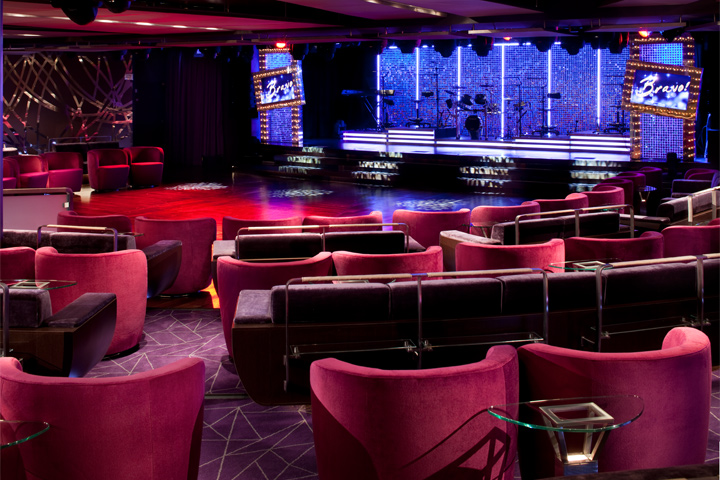
Show/Lounge
- Card Room
- Casino
- Disco/Nightclub
- Movies
- Movies Under the Stars®
- Theater/Show Lounge
- Fitness Center
- Fitness Classes
- Sauna/Steam Room
- Educational Programs
- Guest Lecturers
- Miniature Golf
- Pool - Outdoor
- Pool - Indoor/Covered
- Water Sports Platform
- Whirlpool/Jacuzzi
- Art Gallery
- Bars/Lounges
- Internet Center
- Library
- Business Center
- Concierge Desk
- Conference Center
- Duty-Free Shops/Boutiques
- Elevators
- Infirmary/Medical Center
- Religious Services
- Safe Deposit Boxes
- Self-Service Laundromat
- Wedding/Vow Renewal
Activities & Services (available for an extra fee)
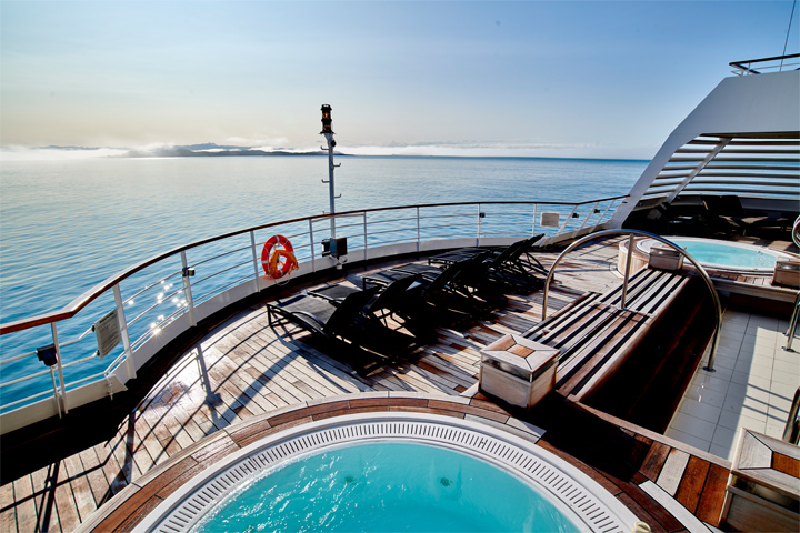
Spa
- Beauty Salon
- Full-Service Spa
- Spa Services/Massage
- Rock-Climbing Wall
- Scuba Diving PADI
- Sports Facilities
- Surfing
- Water Park Arena
- Water Slide
- Dry Cleaning/ Laundry Service
Costco Travel makes every effort to verify the accuracy of all information provided. Additional fees for amenities or services may be charged by the cruise line. Amenities or services may be discontinued or revised by the cruise line without notice. Staterooms designated as wheelchair-accessible do not necessarily meet ADA requirements. Costco Travel is not responsible for inaccuracies or provider modifications.
Dining
Main Dining
The Restaurant: Come when you like, with whom you please, and be seated as you wish. The room is beautiful, the cuisine is exquisite, and the service is simultaneously flawless, friendly and fun.
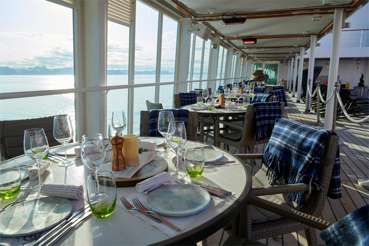
The Colonnade
Casual Dining
Coffee Bar: Enjoy a specialty crafted espresso just the way you like it.
Earth & Ocean: Each evening, the skilled chefs create an imaginative array of fresh, inventive dishes—a sophisticated menu celebrating eclectic traditional flavors from around the world, served in a relaxed setting under the stars for a distinctive dining experience unlike any other on board.
Observation Bar: A stunning round lounge with a square bar and panoramic views. Early Risers’ Coffee and Tea is served here every morning, and piano music makes it a great choice for drinks and conversation before and after dinner.
Seabourn Square: Whether you're looking for a place to enjoy your newspaper in the morning or want to socialize with your fellow passengers, Seabourn Square is what you're looking for. This inviting lounge offers plush seating, cocktail tables, a library, computer terminals, a coffee bar, and Guest Services staff.
Solis: Offering light, modern Mediterranean cuisine bursting with color and character, prepared fresh and entirely from scratch.
The Club: Open for afternoon tea then transforms into a dance club in the evening. Socialize while enjoying cocktails, live music, and great company. Serving a variety of light sushi bites freshly made to order each evening.
The Colonnade: The more casual, indoor/outdoor alternative features an open kitchen, lavish buffets or table service for breakfasts and lunch, and serves regionally themed, bistro-style dinners with table service nightly.
The Patio: Relaxed poolside dining offering luncheon buffets, salads, soups, grilled specialties and freshly baked pizza. Dinners feature a full menu in an alfresco setting.
Sky Bar: A place to enjoy a refreshing tropical beverage during the day, or an evening cocktail under the stars.
In-Suite Dining: A varied menu available around the clock for service in your suite. You may also order dinner from The Restaurant menu and have your meal served, course by course, in your suite or on your veranda.
Times, costs and other specifics are outside the control of Costco Travel. All information is at the sole discretion of the cruise line and is subject to change without notice. Dining time and table size preferences are submitted to the cruise line on a first-come, first-served request basis and are confirmed aboard ship. Questions, concerns and/or special needs regarding dining arrangements must be addressed with the maitre d' hotel aboard ship. Every effort is made to accommodate travelers' preferences; however, Costco Travel cannot guarantee dining arrangements. In specialty restaurants, space is limited and reservations are recommended. A cover charge and dress code may apply.
Staterooms
All Ocean View Suites feature a large picture window, comfortable living area, queen-size bed or two twin beds, dining table for two, walk-in closet, interactive flat-screen television with music and movies, fully stocked bar and refrigerator, makeup vanity, spacious bathroom with separate tub and shower. Approximately 295 sq. ft. (28 sq.m.) of inside space.
- Ocean View Suite with Large Picture Window (Category: A1)

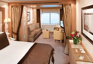
Category: A1
All Ocean View Suites feature a large picture window, comfortable living area, queen-size bed or two twin beds, dining table for two, walk-in closet, interactive flat-screen television with music and movies, fully stocked bar and refrigerator, makeup vanity, spacious bathroom with separate tub and shower.
Approximately 295 sq. ft. (28 sq.m.) of inside space.
- Ocean View Suite with Large Picture Window (Category: A)
Category: A
All Ocean View Suites feature a large picture window, comfortable living area, queen-size bed or two twin beds, dining table for two, walk-in closet, interactive flat-screen television with music and movies, fully stocked bar and refrigerator, makeup vanity, spacious bathroom with separate tub and shower.
Approximately 295 sq. ft. (28 sq.m.) of inside space.
- Interline Guarantee Rate - Suite (Category: RR)
Category: RR
This category can be booked for a special rate, guaranteed to you. Please note that the category is not associated at the time of booking with a specific stateroom, deck, bedding configuration or other particular settings. The assignment of an actual cabin will be performed during your check-in. The cabin can be anywhere on the ship.
- Guarantee - Suite (Category: OS)
Category: OS
This category can be booked for a special rate, guaranteed to you. Please note that the category is not associated at the time of booking with a specific stateroom, deck, bedding configuration or other particular settings. The assignment of an actual cabin will be performed during your check-in. The cabin can be anywhere on the ship.
All Veranda Suites feature a full-length window and glass door to private veranda, comfortable living area, queen-size bed or two twin beds, dining table for two, walk-in closet, interactive flat-screen television with music and movies, fully stocked bar and refrigerator, makeup vanity, spacious bathroom with separate tub and shower.
- Veranda Suite (Category: V4)
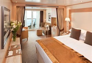
Category: V4
All Veranda Suites feature a full-length window and glass door to private veranda, comfortable living area, queen-size bed or two twin beds, dining table for two, walk-in closet, interactive flat-screen television with music and movies, fully stocked bar and refrigerator, makeup vanity, spacious bathroom with separate tub and shower.
- Veranda Suite (Category: V3)
Category: V3
All Veranda Suites feature a full-length window and glass door to private veranda, comfortable living area, queen-size bed or two twin beds, dining table for two, walk-in closet, interactive flat-screen television with music and movies, fully stocked bar and refrigerator, makeup vanity, spacious bathroom with separate tub and shower.
- Veranda Suite (Category: V2)
Category: V2
All Veranda Suites feature a full-length window and glass door to private veranda, comfortable living area, queen-size bed or two twin beds, dining table for two, walk-in closet, interactive flat-screen television with music and movies, fully stocked bar and refrigerator, makeup vanity, spacious bathroom with separate tub and shower.
- Veranda Suite (Category: V1)
Category: V1
All Veranda Suites feature a full-length window and glass door to private veranda, comfortable living area, queen-size bed or two twin beds, dining table for two, walk-in closet, interactive flat-screen television with music and movies, fully stocked bar and refrigerator, makeup vanity, spacious bathroom with separate tub and shower.
- Guarantee - Suite (Category: SV)
Category: SV
This category can be booked for a special rate, guaranteed to you. Please note that the category is not associated at the time of booking with a specific stateroom, deck, bedding configuration or other particular settings. The assignment of an actual cabin will be performed during your check-in. The cabin can be anywhere on the ship.
- Interline Guarantee Rate - Balcony (Category: RB)
Category: RB
This category can be booked for a special rate, guaranteed to you. Please note that the category is not associated at the time of booking with a specific stateroom, deck, bedding configuration or other particular settings. The assignment of an actual cabin will be performed during your check-in. The cabin can be anywhere on the ship.
All Penthouse Suites on board feature a comfortable living area, glass door to private veranda, queen-size bed or two twin beds; walk-in closet with personal safe, two flat-screen TV with music and movies, fully stocked bar and refrigerator, writing desk with personalized stationary, makeup vanity, spacious bathroom with separate tub and shower, plush robes, slippers hair dryer and 110/220V AC outlets.
- Grand Suite (Category: GR)
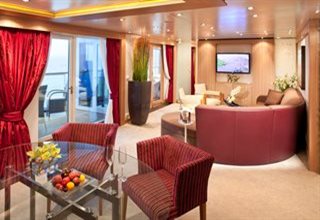
Category: GR
Suites on board feature a comfortable living area, private veranda, queen-size-bed or two twin beds; walk-in closet with personal safe, interactive flat-screen TV with music and movies, fully stocked bar and refrigerator, writing desk with personalized stationary, makeup vanity, spacious bathroom with separate tub and shower, plush robes, slippers, hair dryer, and 110/220V AC outlets.
- Wintergarden Suite (Category: WG)
Category: WG
Suites on board feature a comfortable living area, private veranda, queen-size-bed or two twin beds; walk-in closet with personal safe, interactive flat-screen TV with music and movies, fully stocked bar and refrigerator, writing desk with personalized stationary, makeup vanity, spacious bathroom with separate tub and shower, plush robes, slippers, hair dryer, and 110/220V AC outlets.
- Signature Suite (Category: SS)
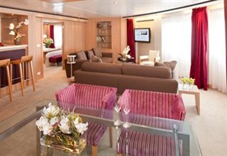
Category: SS
Suites on board feature a comfortable living area, private veranda, queen-size-bed or two twin beds; walk-in closet with personal safe, interactive flat-screen TV with music and movies, fully stocked bar and refrigerator, writing desk with personalized stationary, makeup vanity, spacious bathroom with separate tub and shower, plush robes, slippers, hair dryer, and 110/220V AC outlets.
- Owner's Suite (Category: O2)
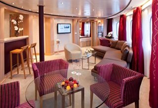
Category: O2
Suites on board feature a comfortable living area, private veranda, queen-size-bed or two twin beds; walk-in closet with personal safe, interactive flat-screen TV with music and movies, fully stocked bar and refrigerator, writing desk with personalized stationary, makeup vanity, spacious bathroom with separate tub and shower, plush robes, slippers, hair dryer, and 110/220V AC outlets.
- Owner's Suite (Category: O1)
Category: O1
Suites on board feature a comfortable living area, private veranda, queen-size-bed or two twin beds; walk-in closet with personal safe, interactive flat-screen TV with music and movies, fully stocked bar and refrigerator, writing desk with personalized stationary, makeup vanity, spacious bathroom with separate tub and shower, plush robes, slippers, hair dryer, and 110/220V AC outlets.
- Penthouse Spa Suite (Category: PS)
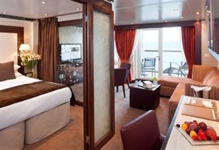
Category: PS
All Penthouse Suites on board feature a comfortable living area, glass door to private veranda, queen-size-bed or two twin beds; walk-in closet with personal safe, two flat-screen TV with music and movies, fully stocked bar and refrigerator, writing desk with personalized stationary, makeup vanity, spacious bathroom with separate tub and shower, plush robes, slippers, hair dryer, and 110/220V AC outlets.
- Penthouse Suite (Category: PH)
Category: PH
All Penthouse Suites on board feature a comfortable living area, glass door to private veranda, queen-size-bed or two twin beds; walk-in closet with personal safe, two flat-screen TV with music and movies, fully stocked bar and refrigerator, writing desk with personalized stationary, makeup vanity, spacious bathroom with separate tub and shower, plush robes, slippers, hair dryer, and 110/220V AC outlets.
- Penthouse Guarantee (Category: PG)
Category: PG
This category can be booked for a special rate, guaranteed to you. Please note that the category is not associated at the time of booking with a specific stateroom, deck, bedding configuration or other particular settings. The assignment of an actual cabin will be performed during your check-in. The cabin can be anywhere on the ship.
Deck Plan
| Symbol | Description |
|---|---|
 | Suite can be reached only via a staircase |
 | Elevator |
 | Wheelchair-accessible suite; roll-in shower only; wheelchair-accessible doorways; Suite 635 also has a tub |
 | Self service launderette |
 | Partially obstructed veranda view |
 | Smaller veranda |
 | Veranda railings are part metal and part glass from floor to teak rail |
 | Subject to noise when anchoring; has all-metal veranda railings, limiting the view |
 | Third guest capacity suite |
Ship Facts
- Ship Name: Seabourn Quest
- Year Built: 2010
- Year Entered Present Fleet: 2011
- Ship Class: O
- Maximum Capacity: 458
- Number of Passenger Decks: 9
- Number of Crew: 295
- Officers' Nationality: International
- Tonnage (GRT): 32,000
- Capacity Based on Double Occupancy: 458
- Country of Registry: The Bahamas
- Total Staterooms: 229
- Crew/Hotel Staff Nationality: International
Costco Travel makes every effort to verify the accuracy of all information provided. Additional fees for amenities or services may be charged by
the hotel, resort or cruise line. Amenities or services may be discontinued or revised by the provider without notice. Hotels, resorts, ships or accommodations
designated as wheelchair-accessible do not necessarily meet ADA requirements. Costco Travel is not responsible for inaccuracies or provider modifications.
Costco Member Reviews
Available Dates & Prices
Terms & Conditions
*Price shown is per person based on double occupancy, is valid for select stateroom categories only, and does include government taxes/fees and gratuities. Click on the Terms & Conditions link below for details.
**Select complimentary shore excursions are for full-fare guests only, capacity controlled and subject to availability. Shore excursion reservations are accepted on a first-come, first-served basis. Please note, available excursions vary by sailing date and day of the week. Government fees and taxes are included. Requested excursions may not be available at time of booking. Supplement will apply on Ventures by Seabourn®, optional shore excursions. Restrictions apply and penalties apply 36 hours prior to shore excursion start date.
†One Digital Costco Shop Card per room/stateroom, per stay. The exact amount of the Digital Costco Shop Card will be calculated during the booking process. The Digital Costco Shop Card promotion is nontransferable and may not be combined with any other promotion. A Digital Costco Shop Card will arrive by email approximately 10 days after the start of your cruise. Click on the Terms & Conditions link below for additional information.
Ship's registry: The Bahamas
Package ID: SBNQUEWOR20270105
Digital Costco Shop Card
Ship Rating
An outstanding luxury cruise experience with an exceptional level of attention to detail. Expect superb service from all levels of officers and staff.
A very good quality all-around cruise experience aboard a ship that offers a range of facilities and services.
A decent, unpretentious cruise experience, with a moderate amount of space and quality in furnishing and fittings.
A modest quality cruise experience with less attention to detail and service.
Expect a very basic cruise experience with minimal attention to service, hospitality and finesse.
Offers some, but not all, of the amenities and services associated with the next highest star rating.